Have a question? Enter it at the bottom of this page in the comments area.
We will answer questions during the live presentation on December 10, 2020.
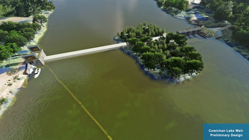
The preliminary design is based on recommendations from the 2018 Cowichan Water Use Plan (WUP), stakeholder engagement, Provincial and Federal legislation and industry accepted practices. Fish passage and riparian environment objectives are the priority in the design and the basis for the project funding.
This project is managed by the CVRD and is made possible through the generous support of the British Columbia Salmon Restoration and Innovation Fund (BCSRIF).
More information will be posted in the following days.
Please join us for a live presentation on December 10, 2020.
Presentation: 6 to 7 PM
Q&A: 7 to 8 PM
Online public link:
https://cowichanvalleyrd.webex.com/cowichanvalleyrd/onstage/g.php?MTID=ef3b29b2c638a185fa0773f84c5c7ebaf
Call-in number: 1-844-992-4726
Call-in access code: 146 385 7474


Have a question? Enter it at the bottom of this page in the comments area. We will answer questions during the live presentation on December 10, 2020.
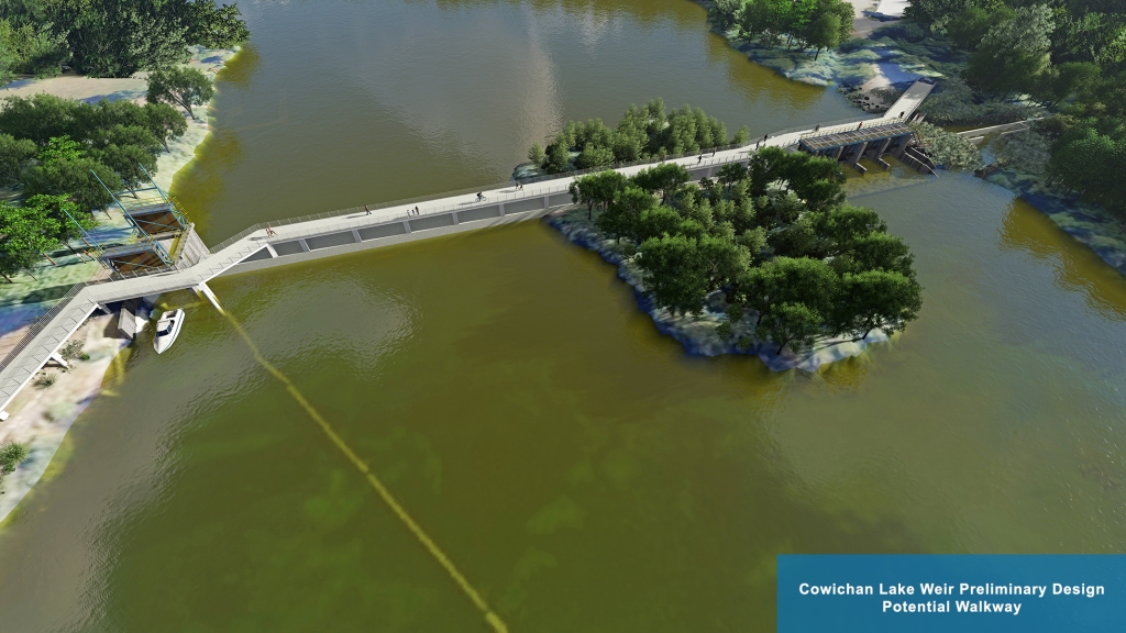
We are currently exploring the option of a walkway over the weir. Further analysis is required to determine the feasibility of this option.


The weir operation has strict operating protocols it must follow often referred to as the ‘Rule Curve’. The rule curve is followed and documented.
A new weir would come through a new water license and a new license holder. The new weir operation would follow newly developed and approved operating criteria.
Compensation, if any, has yet to be determined as we are a long way away from fully understanding the impact of the raising the weir.
The Shoreline Assessment project will determine the impact of raising the weir will have to the perimeter shoreline of the lake. Individual property owners will still need to engage a Qualified Environmental Professional and assess the riparian area if an owner wishes to do any personal work in the riparian area.
We support the opportunity for education and information when this project goes ahead. It is too early to determine what information will be displayed and in what format. Work has not been done to this level of detail.
The future water license holder will be the owner and operator of a new weir and would pay all the associated costs. This has not yet been determined. The new owner would need to decide what additional aspects would be incorporated
You have raised a good point about considering a possible portage. We will add that to our list of items to consider.
The new ownership structure is not yet clear. The owner will be the new water license holder and will have responsibility for the application, operation, maintenance and repairs. These projects (new weir design and the shoreline assessment project) will inform the new water license holder what they should expect in terms of costs, timing and property owner impacts.
A cold water system is being designed into the design to optimize fish habitat and attraction.
A pedestrian walkway is being designed. Because it is an option, and not necessary to make the weir function, it will be designed and costed for the future owner to consider whether or not it will be included.
A pedestrian walkway is a must for this project. I encourage the designers to include this feature.
I add my support to the suggestion that recreational whitewater features be incorporated in the design of the weir itself, or its outflow area. A couple of examples that I’ve seen are in downtown Reno, Nevada, and on the Kananaskis river in Alberta. I’ve travelled to Alberat to use the play features on the Kananaskis river, and it attracts both users and spectators.
In the picture titled “Preliminary Design”, the overflow wier appears to be a flat-slab type. Is this correct, or is it like the inset picture listed as “Overflow Wier – Replace”? The inset picture looks like a design that could form a whitewater play feature with modest modifications. This would have a modest cost if incorporated at initial build time, but would be much more expensive to add later. I think a weir built with recreation in mind also tends to be safer for the public should anyone be in the water in the area.