Have a question? Enter it at the bottom of this page in the comments area.
We will answer questions during the live presentation on December 10, 2020.
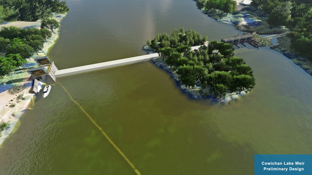
The preliminary design is based on recommendations from the 2018 Cowichan Water Use Plan (WUP), stakeholder engagement, Provincial and Federal legislation and industry accepted practices. Fish passage and riparian environment objectives are the priority in the design and the basis for the project funding.
This project is managed by the CVRD and is made possible through the generous support of the British Columbia Salmon Restoration and Innovation Fund (BCSRIF).
More information will be posted in the following days.
Please join us for a live presentation on December 10, 2020.
Presentation: 6 to 7 PM
Q&A: 7 to 8 PM
Online public link:
https://cowichanvalleyrd.webex.com/cowichanvalleyrd/onstage/g.php?MTID=ef3b29b2c638a185fa0773f84c5c7ebaf
Call-in number: 1-844-992-4726
Call-in access code: 146 385 7474


Have a question? Enter it at the bottom of this page in the comments area. We will answer questions during the live presentation on December 10, 2020.
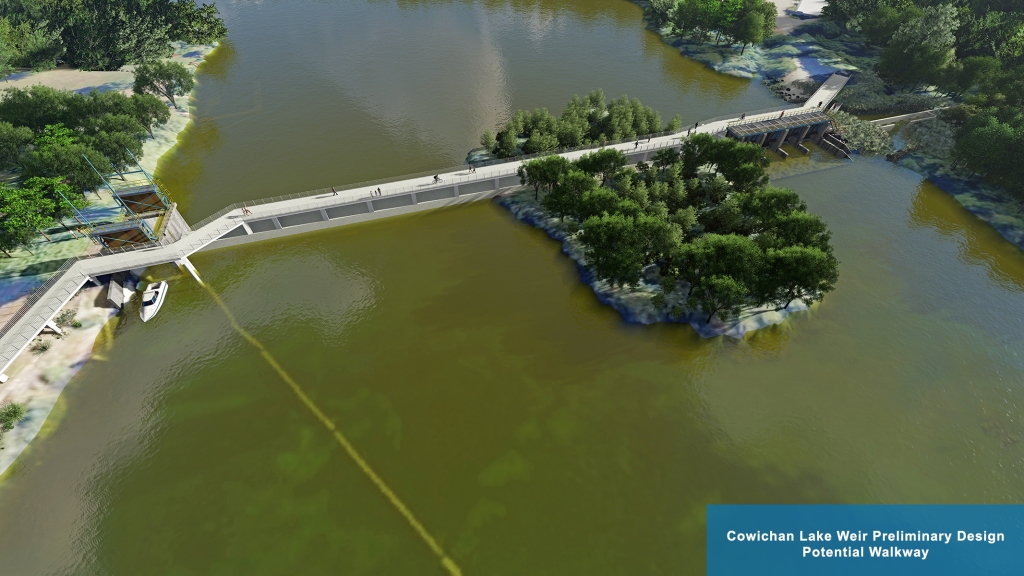
We are currently exploring the option of a walkway over the weir. Further analysis is required to determine the feasibility of this option.


Who will run the weir? Currently Brian Houle of catalyst is on controls. And by the time they decide to close control gates in the spring. water has flowed down River and lake level is well below weir hieght. Also after your study of the lake. What have you determined the effect will be on lake front owners and how will they be compensated for the added hieght and winter flood brought on by more water being held back.
Huge loss of opportunity if a walkway isn’t incorporated. I’d love to see some benches as well.
I’m very interested in the control ability of the proposed new Weir. Can you elaborate on is the system a manual, (fully man or woman operated), semi automated (a system with some man or woman oversite) or fully automated system (probably monitored from a remote screen).
This question comes from a belief that earlier, more timely control in late winter or early spring could possibly even out the highs and low Lake levels we have experienced in the past leading into the late spring early summer time periods. Just so you know I think you have presented a very interesting and informative plan here and are to be congratulated.
One further question. The current discharge capacity of the control gates when fully open is 48 cms. Will the discharge capacity of the new weir be different?
A few questions. 1. The graphic suggests that an inflatable bladder structure will be installed on the top of the weir. Is this part of the proposed design? Does this mean the height of the weir would be lowered in the fall when off control? 2. Has your modelling of lake levels created by the new weir shown a decrease in the occurence of very low lake levels like we suffered in 2019? 3. Is information signage and an education centre or kiosk included in the design? Thanks for all your good work on this project.
I’d like to hear more about the cold water release system. I have been doing some water quality monitoring and I know the water gets too warm for fish habitat by late summer when slow and shallow. Will the cold water release system help to keep the water temperature in the river cooler?
I would like to see a walkway in the development of the weir. To take educational classes to the new Weir encouraging the younger generations to understand the concept behind the weir. School tours. Secondly it would help the tourist in Lake Cowichan to view the weir and have a better understanding of the weir and encouraging respect for the lake / river. Lastly, for the enjoyment of the residents of Lake Cowichan.
Please consider the possibilities it opens with a new walkway incorporated in the plans.
Thank you
It would be a shame if a walkway was not incorporated into the design. There is no need to make it extravagant and I’m sure funding could be obtained by reasoning that it would encourage more walking and biking and less vehicle use. (Climate Change Initiative).
I seem to remember that at discussions earlier (years ago) a walk way across the new weir was mentioned, so that residents and visitors could walk from one side of the river to the other side. Looking at the preliminary design that feature seems to be left out.
How will the design of the new weir minimize the impact on lake properties during seasonal high water and has there been any modeling done on lake levels with a new higher weir throughout the year?