Have a question? Enter it at the bottom of this page in the comments area.
We will answer questions during the live presentation on December 10, 2020.
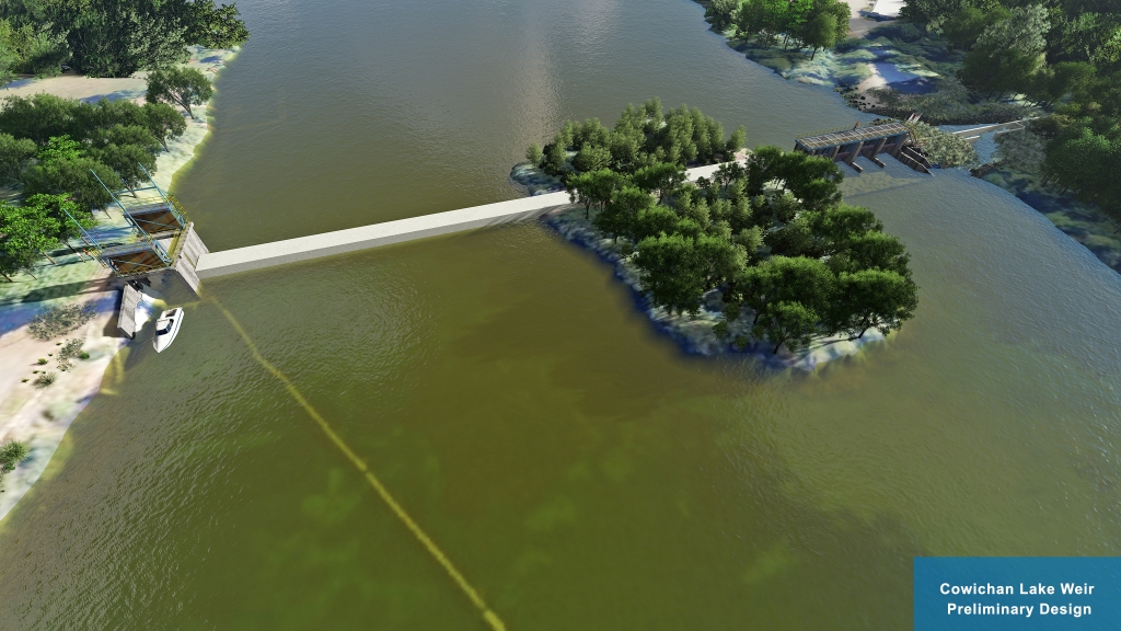
The preliminary design is based on recommendations from the 2018 Cowichan Water Use Plan (WUP), stakeholder engagement, Provincial and Federal legislation and industry accepted practices. Fish passage and riparian environment objectives are the priority in the design and the basis for the project funding.
This project is managed by the CVRD and is made possible through the generous support of the British Columbia Salmon Restoration and Innovation Fund (BCSRIF).
More information will be posted in the following days.
Please join us for a live presentation on December 10, 2020.
Presentation: 6 to 7 PM
Q&A: 7 to 8 PM
Online public link:
https://cowichanvalleyrd.webex.com/cowichanvalleyrd/onstage/g.php?MTID=ef3b29b2c638a185fa0773f84c5c7ebaf
Call-in number: 1-844-992-4726
Call-in access code: 146 385 7474


Have a question? Enter it at the bottom of this page in the comments area. We will answer questions during the live presentation on December 10, 2020.
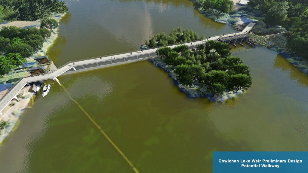
We are currently exploring the option of a walkway over the weir. Further analysis is required to determine the feasibility of this option.


How will the design of the new weir minimize the impact on lake properties during seasonal high water and has there been any modeling done on lake levels with a new higher weir throughout the year?
Modelling will be completed as part of the Shoreline Assessment project to be completed by mid 2022. The new weir shouldn’t impact the high winter water levels because once the weir is overtopped, the flow (and thus lake elevation) is then controlled by the narrow river valley by the Greendale Trestle.
A pedestrian walkway is a must and should be included in all aspects of the design.
I seem to remember that at discussions earlier (years ago) a walk way across the new weir was mentioned, so that residents and visitors could walk from one side of the river to the other side. Looking at the preliminary design that feature seems to be left out.
It would be a shame if a walkway was not incorporated into the design. There is no need to make it extravagant and I’m sure funding could be obtained by reasoning that it would encourage more walking and biking and less vehicle use. (Climate Change Initiative).
We are designing a walkway into the project as an option. Ultimately it will be up to the new owner/water license owner to decide whether or not to include one.
You were too quick onto the website and hadn’t included that picture yet. We are designing a walkway into the project as an option. Ultimately it will be up to the new owner/water license owner to decide whether or not to include one.
I would like to see a walkway in the development of the weir. To take educational classes to the new Weir encouraging the younger generations to understand the concept behind the weir. School tours. Secondly it would help the tourist in Lake Cowichan to view the weir and have a better understanding of the weir and encouraging respect for the lake / river. Lastly, for the enjoyment of the residents of Lake Cowichan.
Please consider the possibilities it opens with a new walkway incorporated in the plans.
Thank you
To add to this question/comment what signage will be put up to help inform/educate visitors about the weir and the wildlife?
We support the opportunity for education and information when this project goes ahead. It is too early to determine what information will be displayed and in what format. Work has not been done to this level of detail.
Great idea. We are designing a walkway into the project as an option. Ultimately it will be up to the new owner/water license owner to decide whether or not to include one.
I’d like to hear more about the cold water release system. I have been doing some water quality monitoring and I know the water gets too warm for fish habitat by late summer when slow and shallow. Will the cold water release system help to keep the water temperature in the river cooler?
The plan is to include enough cold water from the deeper section of the lake to lower the temperature to just below lethal temperature. Of course there are many variables but early indications suggest we can help the situation out with a cold water system for the month or two where temperatures are near lethal for juvenile fish. The release of cold water should also attract fish into the fish passage system to access the lake.
A few questions. 1. The graphic suggests that an inflatable bladder structure will be installed on the top of the weir. Is this part of the proposed design? Does this mean the height of the weir would be lowered in the fall when off control? 2. Has your modelling of lake levels created by the new weir shown a decrease in the occurence of very low lake levels like we suffered in 2019? 3. Is information signage and an education centre or kiosk included in the design? Thanks for all your good work on this project.
An inflatable bladder structure on top of the weir is not deemed necessary and is no longer part of the design.
Modelling of lake levels have not yet been completed. A new weir would reduce the probability that very low lake levels would occur but ultimately extreme climate events will dictate when that happens.
Information and signage have been discussed but have not been designed at this stage in the process.
One further question. The current discharge capacity of the control gates when fully open is 48 cms. Will the discharge capacity of the new weir be different?
Yes, as the water is raised the throughput capacity of the gates also increased due the increased head. The capacity will go up to about 70 cms.
I’m very interested in the control ability of the proposed new Weir. Can you elaborate on is the system a manual, (fully man or woman operated), semi automated (a system with some man or woman oversite) or fully automated system (probably monitored from a remote screen).
This question comes from a belief that earlier, more timely control in late winter or early spring could possibly even out the highs and low Lake levels we have experienced in the past leading into the late spring early summer time periods. Just so you know I think you have presented a very interesting and informative plan here and are to be congratulated.
The plan is to be able to control the new weir from anywhere but to always have a person at the controls.
Timely control is critical to any control structure such as this. An approved operating ‘rule curve’ or criteria will be developed with the new weir that should take into account varying needs and climactic conditions.
Huge loss of opportunity if a walkway isn’t incorporated. I’d love to see some benches as well.
Good point. We will design a walkway and see if the final owner will incorporate it into final construction.
Who will run the weir? Currently Brian Houle of catalyst is on controls. And by the time they decide to close control gates in the spring. water has flowed down River and lake level is well below weir hieght. Also after your study of the lake. What have you determined the effect will be on lake front owners and how will they be compensated for the added hieght and winter flood brought on by more water being held back.
The future water license holder will own and operate the new weir.
The existing weir controls follow a provincially approved operating ‘rule curve’ which Catalyst must follow. These rules are followed and documented. The new weir will have a newly approved operating rule curve.
The shoreline assessment project will determine the impact to the shoreline and thus owner’s properties. The project will be completed mid 2022. This information will then help the regulators and the new water license holder determine any compensation issues.
A question — Historically, weirs elsewhere have earned reputations as “drowning machines” because when water flows over the top, it forms a dangerous hydraulic at the base. Anyone who drifts over the top of the weir, or floats/boats up to the base of weir, would be trapped in the recirculating hydraulic. Will our new weir include design features which will ensure safety?
Public safety is a key principle in our design process. We will ensure this continues through to final design. Currently there is a continuous log boom that directs boating traffic away from the weir structure and into the boat lock area.
There was strong support expressed by responents to the weir design survey for investigating possible ways to enhace paddlesport activities as part of the new weir design exercise. Was this done? And if not ( I don’t see any elements in this report so far) can further design work be done once the basic structure is finalised? Looking forward to hearing more on Thursday.
Just wanted to confirm that this is a weir not a dam. So at what water level will the water flow over the top of the weir?
This is a weir and a dam. When the water flows uncontrolled over the weir, it operates as a weir (typically the winter months) and it operates as a dam when the water level is controlled through the 4 control gates (typically spring to late fall). Regardless of what it is called, it is governed by the same BC Dam Safety design regulations.
The current weir has been mismanaged in recent years. All the winter water has been allowed to drain out causing a (false) drought in the summer and fall months. What assurances do lakefront property owners have that there will be someone properly managing the lake level to ensure that there is enough room in the lake for the fall and winter rains. Lake level management is a 24/7/365 job. Will the management of the new weir recognize that fact? What will be done for property damage due to the 27 inch increase of the weir. How will the government compensate lakefront owners for encroaching on their land and will there also be retroactive compensation for the initial installation of the weir which was promised and never realized?
The weir operation has strict operating protocols it must follow often referred to as the ‘Rule Curve’. The rule curve is followed and documented.
A new weir would come through a new water license and a new license holder. The new weir operation would follow newly developed and approved operating criteria.
Compensation, if any, has yet to be determined as we are a long way away from fully understanding the impact of the raising the weir.
Wow. Compensation, if any??? The water is being stored on lakefront property owners’ property. I think that before anything is started there had better be a very full understanding of the impact of the raising of the weir into a dam. Currently the water level in the lake is lapping at our home foundations. If it goes much higher and a storm similar to December 2019 occurs we will no longer have a home. I know there are many lakefront property owners who will be adversely affected by high water levels.
The Shoreline Assessment Project is the project set out to determine the impact of a new weir and is scheduled to be complete by mid 2022. This work is meant to inform the future new water license holder of the whole picture before applications or approvals. No construction nor new water licenses will be approved until a full understanding is reached.
The current water level is at around 164 meters elevation which is the average high water mark that has been measured for the past 40 years.
The weir is submerged every winter and does not restrict flow. It is the natural river features downstream of the weir that restrict flow in the winter and determines the high lake levels. The new weir at 163.07m elevation would also be submerged during the high winter water events.
It would be GREAT if some recreational whitewater play features could be included. These kinds of features (e.g. a surf wave) have been very popular in other locations where they have been built. They provide a hub for fun, and for learning, and they draw people to the area thus providing potential economic activity (restaurants, equipment rentals, lessons, etc.)
I love the idea of a play wave of the cost is reasonable.
With a project of this magnitude, the overall impacts on the community will be lasting and probably profound. From what I understand, recreational values are appreciated by the planners but the funding for this is not easily obtained, and at this point may not be available. It seems a shame to not take the time to do this right the first time. Other communities are dealing with aging infrastructure, and so many (eg Boise ID, Bend OR, Oklahoma City, Ottawa ON and many more) have incorporated whitewater kayaking features, extensive trail networks, riverside recreational sites of interest, etc and these have helped those communities create economic opportunity, have had positive influence on fish habitat, and have positively impacted resident quality of life. I would love to see this happen in this case as well.
Hello– This is àn opportunity to include paddle sports in the mix: for locals and for tourists these are attractions. Why isn’t there a paddling play park in the plans?
There was previous support expressed by paddlers to explore the possibility of creating whitewater features into the weir design. I don’t see any elements in this information regarding incorporating whitewater play features. Can these features be incorporated. Looking forward to hearing more on Thursday
The Cowichan has been designated a “Canadian Heritage River.” Here’s a quote from the Canadian Heritage Rivers System: “Canada’s Heritage Rivers are recognized nationally for their outstanding NATURAL, CULTURAL, and RECREATIONAL heritage…” Early in the process of designing the Weir, there was a Public Advisory Group tasked with establishing initial parameters for the Design — were all three Heritage River criteria considered in that initial process? Were there representatives included in the Public Advisory Group to advocate specifically for all three criteria? And have features been specifically included in the current design to honour those criteria?
When I want to add boulders to protect my property from erosion from high lake levels I have to get a Riparian Assessment. Has a Riparian assessment been done of the entire lake to determine the effects of a higher lake level?
The Shoreline Assessment project will determine the impact of raising the weir will have to the perimeter shoreline of the lake. Individual property owners will still need to engage a Qualified Environmental Professional and assess the riparian area if an owner wishes to do any personal work in the riparian area.
This has a great opportunity to be a feature for this town in many different avenues. From the walk way providing access to and from town, to the fishway providing a naturalized path for fish. As a river professional I also see this being a great opportunity to provide a safe river location for people to recreate . A feature that could be used to play and educate would be a great asset to the south island and beyond. Question, this was brought up in the prelims as showing interest from the public .is there a known avenue to explore this option further on both funding and procuring? or has this boat sunk?
Has there been serious consideration for paddlesport features, such as whitewater play waves in the new design? It would be a shame not to take this opportunity to enhance these recreational opportunities.
I’m extremely pleased to find this web site. I need to to thank you for ones time for this particularly wonderful read!! I definitely appreciated every little bit of it and i also have you saved to fav to see new things in your site.
It would be a terrible missed-opportunity if no recreational features were incorporated into this design. Whitewater paddling is a fast-growing sport in Canada, and Vancouver Island in particular is becoming recognized for its abundance of wet-weather whitewater opportunities. Consequently, the population of skilled paddlers (both seasonal and permanent) on the Island is higher every year. Many of these paddlers would pay to participate in a reliable-flow whitewater recreation spot, particularly in the dry season. From the looks of the preliminary weir design, it appears likely that even a modest whitewater ‘feature’ could be incorporated into or below the fish-passage design. Fees collected to participate in such a recreational feature would almost certainly pay for the feature itself in the short term. In the longer term, maintenance and upkeep could likely be significantly assisted from continued recreational fee collection. Whitewater parks in other areas of Canada and the United States have been phenomenally successful. Is there any reason to believe that a whitwater feature added to this design would be anything less than a boon to the project and the community? If economic considerations are the reason for declining such an addition at this time, have any cost-estimates or feasibilty assessments been gathered that could be shared with the paddling community such that paddlers could investigate soliciting alternative sources of funding? Given that a number of paddlers on Vancouver Island have visited other man-made whitewater recreation facilities, would the decision-makers on this project consent to share any information on feasibility and cost publically so that those experienced with such can provide design feedback (and/or solicit such from the designers of other parks)? Thank you.
There has ben a lot of support for a playpark for local paddling enthusiasts, spectators and visitors to actually connect with the water. Is there a reason why this is not part of the plan? In these trying times we are all looking for ways to cope with the stress we are all feeling and enjoy the outdoors.
This play park idea is not a new idea and in the US they are quite common and help the local economy immensely.
Hi,
Is there plans to look at incorporating potential for a surf wave or other river features into the design? Having worked at courses in Nottingham, UK and Sydney, Australia. They were places with walkways, multiple user groups, and the community benefitted as a result. Another example would be Harvie passage in Calgary, AB. Look forward to hearing the discussion tonight.
The Cowichan River is one of the most popular whitewater kayaking rivers on Vancouver Island. Myself and many many others paddle various sections of the river all year long. Because of this, I know I’m not alone when I say that the weir project is a real opportunity to develop some whitewater play features at this section of the river. There are many many other locales throughout North America that have done this successfully with notable benefits to the local community. This includes the Deschutes River in Bend Oregon, the Bow River in Calgary Alberta. Benefits include revenue generated from paddlers travelling to and spending time in the community. I will say that paddlers are a respectful group of people, who consider safety as a priority when managing risk. This is an integral part of the sport and how we support each other when on the river.
As an avid paddler living on Vancouver Island, I am very supportive of developing whitewater play features on the Cowichan River as part of the weir project. Thanks for the opportunity to comment!
There has been many great suggestions on incorporating aspects to the new weir that would benefit the community. Where would these funds come from to add these aspects to the design?
More importantly, has ownership and control of weir been determined for the future?
The future water license holder will be the owner and operator of a new weir and would pay all the associated costs. This has not yet been determined. The new owner would need to decide what additional aspects would be incorporated
I echo the thoughts about the need for whitewater recreation features to be incorporated into the design plan. The economic and social benefits would soon be realized. It is a tremendous opportunity to establish a landmark for recreational outdoor activities on beautiful Vancouver Island for all to enjoy.
I would like to add my support for exploring the development of a safe structure for all, whether it be for watercraft, swimmers, tubers or those who finds themselves in the water by accident. I can think of no better way to do this than to have it designed with safe recreational use in mind. This will have the added benefit of being a huge resource for the community as well. One only needs to look at recent dam removal efforts to the south, particularly in Colorado. Whitewater sports have flourished in countless European communities where existing waterways, weirs and dams have built modest structures for safe whitewater use. It would be a missed opportunity to not include a feasibility study for incorporating these considerations into the cost of building the new weir.
How will those who want to paddle from the lake into the river be accommodated? Before the weir I’m sure that one could just paddle away without any trouble. Now the option seems to be to use the lock (energy/time) or attempt to portage. The portage option would be nice to have – takeout above the weir at the lock is currently easy, but putting in below isn’t. What plans are there to facilitate a easy portage that wasn’t necessary before the weir and removed by the weir after its construction?
You have raised a good point about considering a possible portage. We will add that to our list of items to consider.
A water park should be talked about for
all the whitewater enthusiasts spectators as it would be beneficial to spectators as well
I see my thoughts have been mentioned in the previous posts. Would like to emphasize a playpark for paddling enthusiasts, spectators and visitors to connect with the water.
I, like many others would love to see a planned project incorporating some whitewater play/boating features to the new Weir. It is a very clean, environment safe sport which can only enhance tourism to the area. The benefits of this in the long run justify any added cost that may be incurred to the project.
I believe the original weir was financed, owned and operated by forest companies, primarily BCFP. The new weir is being financed by grants from fisheries and other government supported organizations. Who will have ownership and operational control of the new weir and be responsible for future maintenence and repair?
The new ownership structure is not yet clear. The owner will be the new water license holder and will have responsibility for the application, operation, maintenance and repairs. These projects (new weir design and the shoreline assessment project) will inform the new water license holder what they should expect in terms of costs, timing and property owner impacts.
If you are building a weir, why not incorporate a feature for white water kayakers? It’s a great opportunity to contribute to an environmentally friendly sport and it will become an asset to the community
If, as we have been told, that the weir is for the benefit of the river ecology and enhancement of the fishery in the river and not for water supply to Catalyst Paper or for tubing or other miscellaneous purposes, then the cold water bypass MUST be incorporated into the weir structure. Why is this only considered to be an “optional” item? Why would this be secondary to recreational uses or aesthetic items such as concrete stamping and signage that the survey seemed to spend a energy and time on.
A cold water system is being designed into the design to optimize fish habitat and attraction.
I would like to second the above comments re a recreational whitewater feature. This has the potential to be a driver for local tourism, recreation, increase the safety of area and an attraction for young families to move to the Cowichan. See Quesnel BC’s waterfront plan for further details on an existing plan from another similar town in BC: https://www.quesnel.ca/sites/default/files/docs/government/quesnel_waterfront_report-final_print_version-small.pdf
I add my support to the suggestion that recreational whitewater features be incorporated in the design of the weir itself, or its outflow area. A couple of examples that I’ve seen are in downtown Reno, Nevada, and on the Kananaskis river in Alberta. I’ve travelled to Alberat to use the play features on the Kananaskis river, and it attracts both users and spectators.
In the picture titled “Preliminary Design”, the overflow wier appears to be a flat-slab type. Is this correct, or is it like the inset picture listed as “Overflow Wier – Replace”? The inset picture looks like a design that could form a whitewater play feature with modest modifications. This would have a modest cost if incorporated at initial build time, but would be much more expensive to add later. I think a weir built with recreation in mind also tends to be safer for the public should anyone be in the water in the area.
A pedestrian walkway is a must for this project. I encourage the designers to include this feature.
A pedestrian walkway is being designed. Because it is an option, and not necessary to make the weir function, it will be designed and costed for the future owner to consider whether or not it will be included.
It’s great to see the preliminary designs for the new weir! From a landscape architecture perspective, I can see the huge benefit of incorporating public engagement with a walkway, benches, viewing platform etc. I’m sure you have a growing list of desired features from the community, as I can see the white water element being particularly sought after. I am wondering what measures have needed to be taken place in the great effort of constructing the new weir and removing the old one in regards to ecological impact and concerns? In particular, the Cowichan Lake Lamprey’s critical habitat falls within this realm. I’m also wondering if the designers have explored any material elements such a textured panels and shelves to create opportunity/habitat for other species as well? An example of this is the Seattle Seawall design in Elliot Bay. There is a chance for this project to be multifunctional, therefore serving more ecosystem services, and providing space for wildlife and humans. Thanks for your feedback, and Happy New Year!
I need to replace 1 of my pilings and am wondering how far the water will be coming in on shoreline after weir is complete
The winter high water levels should not be any different after a new weir is built. During high water levels the water will flow over the new weir as it does today with the existing weir. The river valley downstream of the weir controls the lake level once the weir is overtopped. The highest water level measured in 1968 was 165.39 meters elevation.
Where the water is on the shoreline is depends on time of year and precipitation.
where’s the boat launch?
The boat launch is planned to stay exactly where it is today. It may be impacted during some of the construction period due to laydown yards and work activity.